VIMS Ground Survey Spreadsheet Guidelines
Please enter your data in the Ground Survey Spreadsheet and submit it to savgdsurvey@vims.edu.
Example:
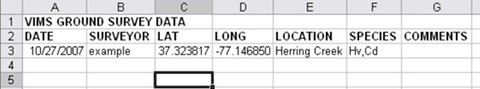
DATE
Please format the date as month/day/year (e.g. 05/05/2007)
SURVEYOR
Add the name of the person who surveyed the area to this column (e.g. orth)
LAT/LONG
Include the latitude and longitude in decimal degrees format (e.g. 39.052650, -76.076200)
The North American Datum of 1983 should be used.
LOCATION
Include the creek, river, point of land, or cove that the ground survey point is in or close to. (e.g. East of Mosquito Island, South of Salter Creek)
SPECIES
Include the species that was found at the location. (e.g. Zm, Rm)
Below is a list of abbreviations that should be used:
Zm - Zostera marina (eelgrass)
Rm - Ruppia maritima (widgeon grass)
C - Chara sp. (muskgrass)
Cd - Ceratophyllum demersum (coontail)
Cl - Callitriche sp. (water-starwort)
Ec - Elodea canadensis (common elodea)
Ed - Egeria densa (water-weed)
Hd - Heteranthera dubia (water stargrass)
Hv - Hydrilla verticillata (hydrilla)
Ms - Myriophyllum spicatum (Eurasian watermilfoil)
N - Najas sp. (naiad)
Nfl - Najas flexilis (northern naiad)
Ngr - Najas gracillima (slender naiad)
Ngu - Najas guadalupensis (southern naiad)
Nm - Najas minor (spiny naiad)
Nt - Nitella sp. (muskgrass)
Pcr - Potamogeton crispus (curly pondweed)
Pe - Potamogeton epihydrus (leafy pondweed)
Pn - Potamogeton nodosus (American pondweed)
Ppc - Stuckenia pectinata (sago pondweed)(Potamogeton pectinatus)
Ppf - Potamogeton perfoliatus (redhead-grass)
Ppu - Potamogeton pusillus (slender pondweed)
S - Sparganium sp. (bureed)
Tn - Trapa natans (water chestnut)
Va - Vallisneria americana (wild celery)
Zp - Zannichellia palustris (horned pondweed)
U - Unknown species composition
COMMENTS
Include any other information in this column
Additional suggestions:
· Please name the file surveyor_date.xls (e.g. jjorth_050507.xls)
· Add other columns if necessary, but make sure to include those listed above. Additional columns will not be included in the final dataset.
An online key to Chesapeake Bay SAV is available from the Maryland Department of Natural Resources web page.
|